


Chasserades - Le Bleymard

nolsim
User
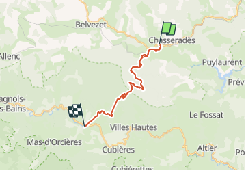

Length
17.4 km

Max alt
1413 m

Uphill gradient
520 m
Km-Effort
24 km

Min alt
1069 m

Downhill gradient
545 m
Boucle
No
Creation date :
2018-08-18 14:09:05.862
Updated on :
2018-08-18 14:09:05.862
--
Difficulty : Medium

FREE GPS app for hiking
 SityTrail
IGN / Geographical institutes
SityTrail Plus
The world is yours!
About
Trail Walking of 17.4 km to be discovered at Occitania, Lozère, Mont Lozère et Goulet. This trail is proposed by nolsim.
Positioning
Country:
France
Region :
Occitania
Department/Province :
Lozère
Municipality :
Mont Lozère et Goulet
Location:
Chasseradès
Start:(Dec)
Start:(UTM)
564692 ; 4933167 (31T) N.
Comments